Geolocate

Cerro Azoguine topographic map

Click on the map to display elevation.

About this map

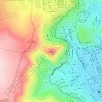
Name: Cerro Azoguine topographic map, elevation, terrain.

Location: Cerro Azoguine, Puno, 05151, Perú (-15.83231 -70.03516 -15.83221 -70.03506)

Average elevation: 3,967 m

Minimum elevation: 3,818 m

Maximum elevation: 4,148 m

Other topographic maps

Click on a map to view its topography, its elevation and its terrain.

Ciudad de los niños

Perú > Puno > Puno

Average elevation: 3,881 m

Gear up for your next adventure:

🧭GPS Outdoor Watch - Smart watch for navigation and fitness tracking in nature
Lightweight Camping Tent - Portable shelter optimized for Canadian backcountry camping
🦶Hiking Shoe Insoles - Added support for high arches and long days on feet
🚲Handlebar Phone Mount - View topographic-map.com live while cycling
🧢Sun Hat - Wide-brim hat for sun protection

As an Amazon Associate, this site earns from qualifying purchases at no extra cost to you.