Geolocate

Corrib topographic map

Click on the map to display elevation.

About this map

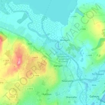
Name: Corrib topographic map, elevation, terrain.

Location: Corrib, Galway, County Galway, Connacht, Ireland (53.27011 -9.12114 53.32234 -9.05498)

Average elevation: 27 m

Minimum elevation: -2 m

Maximum elevation: 104 m

Other topographic maps

Click on a map to view its topography, its elevation and its terrain.

Knocknagoneen

Ireland > County Galway > Galway

Average elevation: 6 m

NUIG Organic Garden

Ireland > County Galway > Galway

Average elevation: 15 m

Blackrock Beach

Ireland > County Galway > Galway

Average elevation: 8 m

Gear up for your next adventure:

Tent Footprint - Protect tent floor and increase durability
🧭GPS Outdoor Watch - Smart watch for navigation and fitness tracking in nature
🥾Trail Hiking Socks - Comfortable socks to prevent blisters and fatigue
🧤Insulated Winter Gloves - Heavy-duty protection for sub-zero Canadian adventures
🧥Softshell Jacket - Windproof and breathable jacket for hiking

As an Amazon Associate, this site earns from qualifying purchases at no extra cost to you.