Geolocate

Malainin topographic map

Click on the map to display elevation.

About this map

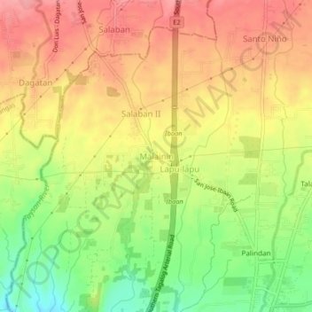
Name: Malainin topographic map, elevation, terrain.

Location: Malainin, Ibaan, Batangas, Calabarzon, 4230, Philippines (13.82120 121.09875 13.86120 121.13875)

Average elevation: 155 m

Minimum elevation: 95 m

Maximum elevation: 201 m

Other topographic maps

Click on a map to view its topography, its elevation and its terrain.

Calumpang River

Philippines > Batangas > Ibaan > Catandala

Average elevation: 93 m

Calumpang River

Philippines > Batangas > Ibaan

Average elevation: 99 m

Coliat

Philippines > Batangas > Ibaan

Average elevation: 113 m

Talaibon

Philippines > Batangas > Ibaan

Average elevation: 142 m

Calumpang River

Philippines > Batangas > Ibaan > Balanga

Average elevation: 84 m

Pangao

Philippines > Batangas > Ibaan

Average elevation: 130 m

Palindan

Philippines > Batangas > Ibaan

Average elevation: 134 m

Taysan River

Philippines > Batangas > Ibaan > Salaban Ⅱ

Average elevation: 139 m

Balanga

Philippines > Batangas > Ibaan

Average elevation: 93 m

Calumpang River

Philippines > Batangas > Ibaan > Balanga

Average elevation: 84 m

Pangao

Philippines > Batangas > Ibaan

Average elevation: 130 m

Gear up for your next adventure:

🥾Waterproof Hiking Shoes - Durable shoes for wet and rugged trails
🥫Freeze-Dried Meals - Lightweight, high-calorie nutrition for multi-day treks
🛶Waterproof Dry Bags - Keep electronics and clothes dry during river crossings
🧥Waterproof Pants - Keep dry during rainy hiking conditions
🔋Emergency Crank Radio - Weather alerts and power without needing batteries

As an Amazon Associate, this site earns from qualifying purchases at no extra cost to you.