
Watou topographic map
Interactive map
Click on the map to display elevation.
About this map
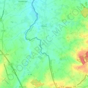
Name: Watou topographic map, elevation, terrain.
Location: Watou, Poperinge, Ypres, Flandre-Occidentale, 8978, Belgique (50.81291 2.59863 50.87766 2.67783)
Average elevation: 25 m
Minimum elevation: 6 m
Maximum elevation: 65 m
Other topographic maps
Click on a map to view its topography, its elevation and its terrain.
Haringe
Belgique > Flandre-Occidentale > Ypres > Poperinge > Roesbrugge-Haringe
Haringe, Roesbrugge-Haringe, Poperinge, Ypres, Flandre-Occidentale, Flandre, 8972, Belgique
Average elevation: 9 m