
Make a donation
Gear up for your next adventure:
As an Amazon Associate, this site earns from qualifying purchases at no extra cost to you.
Skale topographic map
Click on the map to display elevation.
Make a donation
Gear up for your next adventure:
As an Amazon Associate, this site earns from qualifying purchases at no extra cost to you.
Skale
Escalles ligt aan de kust van het Nauw van Calais, behorend tot de Opaalkust. De hoogte van de gemeente varieert van 0 tot 154 meter, en de kerk bevindt zich op een hoogte van 47 meter boven zeeniveau, aan de voet van de 151 meter hoge Mont d'Hubert. Vanaf Escalles voert een weg steil omlaag naar zee, de Cran d'Escalles. In de onmiddellijke nabijheid van het dorp ligt Cap Blanc-Nez, met krijtrotsen.
Make a donation
Gear up for your next adventure:
As an Amazon Associate, this site earns from qualifying purchases at no extra cost to you.
About this map
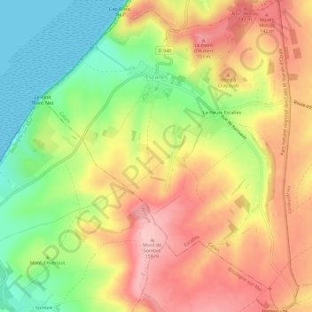
Name: Skale topographic map, elevation, terrain.
Average elevation: 84 m
Minimum elevation: 0 m
Maximum elevation: 160 m
Make a donation
Gear up for your next adventure:
As an Amazon Associate, this site earns from qualifying purchases at no extra cost to you.
Other topographic maps
Click on a map to view its topography, its elevation and its terrain.
Make a donation
Gear up for your next adventure:
As an Amazon Associate, this site earns from qualifying purchases at no extra cost to you.
Cap Gris-Nez
Frankrijk > Hauts-de-France > Pas-de-Calais > Audinghen > Le Gris-Nez
Average elevation: 14 m
Make a donation
Gear up for your next adventure:
As an Amazon Associate, this site earns from qualifying purchases at no extra cost to you.
Plage d'Audreselles
Frankrijk > Hauts-de-France > Pas-de-Calais > Audresselles
Average elevation: 13 m
Make a donation
Gear up for your next adventure:
As an Amazon Associate, this site earns from qualifying purchases at no extra cost to you.