
Make a donation
Gear up for your next adventure:
As an Amazon Associate, this site earns from qualifying purchases at no extra cost to you.
Portalegre topographic map
Click on the map to display elevation.
Make a donation
Gear up for your next adventure:
As an Amazon Associate, this site earns from qualifying purchases at no extra cost to you.
Portalegre
A cidade encontra-se a uma altitude entre os 400 e 600 metros, na zona de transição entre a paisagem relativamente plana, mas com muitas colinas pouco elevadas a sul e oeste, e o sistema montanhoso da Serra de São Mamede, que a rodeia a norte, leste e sueste.
Make a donation
Gear up for your next adventure:
As an Amazon Associate, this site earns from qualifying purchases at no extra cost to you.
About this map
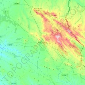
Name: Portalegre topographic map, elevation, terrain.
Location: Portalegre, Alto Alentejo, Alentejo, 7300-139, Portugal (39.13113 -7.59339 39.45113 -7.27339)
Average elevation: 416 m
Minimum elevation: 196 m
Maximum elevation: 1,019 m
Make a donation
Gear up for your next adventure:
As an Amazon Associate, this site earns from qualifying purchases at no extra cost to you.