
Make a donation
Gear up for your next adventure:
As an Amazon Associate, this site earns from qualifying purchases at no extra cost to you.
Sauris / Zahre topographic map
Click on the map to display elevation.
Make a donation
Gear up for your next adventure:
As an Amazon Associate, this site earns from qualifying purchases at no extra cost to you.
Sauris / Zahre
Sauris (German: Zahre) is a comune (municipality) in the Regional decentralization entity of Udine in the Italian region of Friuli-Venezia Giulia. At an elevation of 1,212 m (3,976 ft), it is the second highest municipality in the region and one of the German language islands in Northeast Italy. Sauris is part of the Alpine pearls cooperation for sustainable tourism.
Make a donation
Gear up for your next adventure:
As an Amazon Associate, this site earns from qualifying purchases at no extra cost to you.
About this map
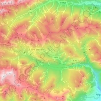
Name: Sauris / Zahre topographic map, elevation, terrain.
Average elevation: 1,467 m
Minimum elevation: 490 m
Maximum elevation: 2,454 m
Make a donation
Gear up for your next adventure:
As an Amazon Associate, this site earns from qualifying purchases at no extra cost to you.
Other topographic maps
Click on a map to view its topography, its elevation and its terrain.
Fusine in Valromana / Weißenfels / Bela Peč / Fusinis
Italy > Friuli – Venezia Giulia > Udine / Udin / Videm > Tarvisio / Tarvis / Trbiž
Average elevation: 967 m
Albana / Ibána / Albane
Italy > Friuli – Venezia Giulia > Udine / Udin / Videm > Prepotto / Prapotno / Prepot
Average elevation: 175 m
Make a donation
Gear up for your next adventure:
As an Amazon Associate, this site earns from qualifying purchases at no extra cost to you.
Scale / Skale
Italy > Friuli – Venezia Giulia > Udine / Udin / Videm > Drenchia
Average elevation: 610 m
Montemaggiore / Brezje
Italy > Friuli – Venezia Giulia > Udine / Udin / Videm > Taipana
Average elevation: 817 m
Monte Tamai
Italy > Friuli – Venezia Giulia > Udine / Udin / Videm > Ovaro / Davâr
Average elevation: 1,588 m
Make a donation
Gear up for your next adventure:
As an Amazon Associate, this site earns from qualifying purchases at no extra cost to you.
Monte Lubia / Ljubija
Italy > Friuli – Venezia Giulia > Udine / Udin / Videm > Pulfero
Average elevation: 795 m
Sandrine
Italy > Friuli – Venezia Giulia > Udine / Udin / Videm > Artegna / Dartigne > Borc dal Steli
Average elevation: 263 m