Geolocate

Ostra topographic map

Click on the map to display elevation.

About this map

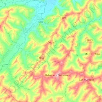
Name: Ostra topographic map, elevation, terrain.

Location: Ostra, Ancona, Marche, Italy (43.55429 13.08304 43.65349 13.19650)

Average elevation: 119 m

Minimum elevation: 26 m

Maximum elevation: 250 m

Other topographic maps

Click on a map to view its topography, its elevation and its terrain.

Gabriella

Italy > Marche > Ancona > Senigallia

Average elevation: 42 m

Gear up for your next adventure:

🚲Heavy Duty Bike Lock - Secure your bike at the trailhead or during stops
🛰️Satellite Messenger - Emergency communication for areas with no cell service
Backpacking Tent - Lightweight tent for long-distance hiking trips
🚑Survival Whistle - Signal for help across long distances in mountains
Camping Groundsheet - Protect your tent from moisture and dirt

As an Amazon Associate, this site earns from qualifying purchases at no extra cost to you.