
Make a donation
Gear up for your next adventure:
As an Amazon Associate, this site earns from qualifying purchases at no extra cost to you.
Bert topographic map
Click on the map to display elevation.
Make a donation
Gear up for your next adventure:
As an Amazon Associate, this site earns from qualifying purchases at no extra cost to you.
About this map
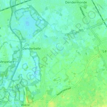
Name: Bert topographic map, elevation, terrain.
Average elevation: 5 m
Minimum elevation: -1 m
Maximum elevation: 14 m
Make a donation
Gear up for your next adventure:
As an Amazon Associate, this site earns from qualifying purchases at no extra cost to you.
Other topographic maps
Click on a map to view its topography, its elevation and its terrain.
Wieze
België > Oost-Vlaanderen > Dendermonde > Lebbeke
Wieze ligt aan de Dender op een hoogte van 5-10 meter. De bodem is lemig en zandlemig. Enkele beken (Windgatbeek, Grote Beek en Steenbeek) lopen in noordwestelijke richting en monden uit in de Dender.
Average elevation: 10 m