Geolocate

Matagbak II topographic map

Click on the map to display elevation.

About this map

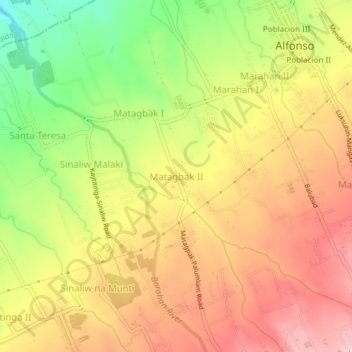
Name: Matagbak II topographic map, elevation, terrain.

Location: Matagbak II, Alfonso, Cavite, Calabarzon, 4123, Philippines (14.10318 120.82154 14.14318 120.86154)

Average elevation: 428 m

Minimum elevation: 312 m

Maximum elevation: 517 m

Other topographic maps

Click on a map to view its topography, its elevation and its terrain.

Amuyong

Philippines > Cavite > Alfonso

Average elevation: 543 m

Amuyong

Philippines > Cavite > Alfonso

Average elevation: 543 m

Gear up for your next adventure:

🧭Orienteering Kit - Tools for map reading and navigation in the wild
🧢Outdoor Visor - Breathable visor for sunny hikes
🛏️Sleeping Bag - Warm and compact sleeping bags for outdoor camping
🧥Thermal Fleece Jacket - Versatile insulation for changing mountain temperatures
🧰Emergency Multi-Tool - Compact multi-tool for outdoor survival

As an Amazon Associate, this site earns from qualifying purchases at no extra cost to you.