
Thank you for supporting this site ❤️
Make a donation
Make a donation
Gear up for your next adventure:
As an Amazon Associate, this site earns from qualifying purchases at no extra cost to you.
Cocapata topographic map
Click on the map to display elevation.
Thank you for supporting this site ❤️
Make a donation
Make a donation
Gear up for your next adventure:
As an Amazon Associate, this site earns from qualifying purchases at no extra cost to you.
About this map
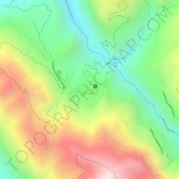
Name: Cocapata topographic map, elevation, terrain.
Location: Cocapata, Municipio Cocapata, Ayopaya, Cochabamba, Bolivia (-16.80327 -66.67260 -16.79686 -66.66593)
Average elevation: 3,246 m
Minimum elevation: 2,914 m
Maximum elevation: 3,640 m
Thank you for supporting this site ❤️
Make a donation
Make a donation
Gear up for your next adventure:
As an Amazon Associate, this site earns from qualifying purchases at no extra cost to you.
Other topographic maps
Click on a map to view its topography, its elevation and its terrain.