Geolocate

Pingdingshan topographic map

Click on the map to display elevation.

About this map

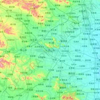
Name: Pingdingshan topographic map, elevation, terrain.

Location: Pingdingshan, Henan, 467000, China (33.13002 112.24168 34.34657 113.68389)

Average elevation: 177 m

Minimum elevation: 56 m

Maximum elevation: 1,097 m

Other topographic maps

Click on a map to view its topography, its elevation and its terrain.

Kaifeng

China > Henan > Gulou District > Xiangguosi Subdistrict

Average elevation: 75 m

Changtai

China > Henan

Average elevation: 84 m

Xinyang

China > Henan > Qianjin Subdistrict

Average elevation: 105 m

Daxingnanjiecun

China > Henan > Tangyin County

Average elevation: 85 m

Gear up for your next adventure:

🧴Insect Repellent - Protect yourself from bugs during outdoor adventures
🥾Mountaineering Boots - Supportive boots for climbing and high-altitude hiking
🥾Lightweight Hiking Shoes - Comfortable shoes for day hikes
🗺️Topographic Maps - Detailed maps to explore trails, mountains, and wilderness areas
🚲Bike Repair Kit - Essential tools for on-trail mechanical issues

As an Amazon Associate, this site earns from qualifying purchases at no extra cost to you.