
Make a donation
Gear up for your next adventure:
As an Amazon Associate, this site earns from qualifying purchases at no extra cost to you.
Agogo topographic map
Click on the map to display elevation.
Make a donation
Gear up for your next adventure:
As an Amazon Associate, this site earns from qualifying purchases at no extra cost to you.
Agogo
Agogo is located at 6.80004 (latitude in decimal degrees), -1.08193 (longitude in decimal degrees) at an elevation/altitude of 396 meters. The average elevation of Agogo in Asante Akim North Municipal is 396 meters.
Make a donation
Gear up for your next adventure:
As an Amazon Associate, this site earns from qualifying purchases at no extra cost to you.
About this map
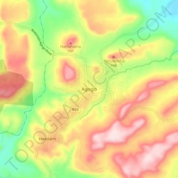
Name: Agogo topographic map, elevation, terrain.
Location: Agogo, Asante-Akim North District, Ashanti Region, Ghana (6.76087 -1.12473 6.84087 -1.04473)
Average elevation: 408 m
Minimum elevation: 208 m
Maximum elevation: 597 m
Make a donation
Gear up for your next adventure:
As an Amazon Associate, this site earns from qualifying purchases at no extra cost to you.