
Thank you for supporting this site ❤️
Make a donation
Make a donation
Gear up for your next adventure:
As an Amazon Associate, this site earns from qualifying purchases at no extra cost to you.
Turgutreis topographic map
Click on the map to display elevation.
Thank you for supporting this site ❤️
Make a donation
Make a donation
Gear up for your next adventure:
As an Amazon Associate, this site earns from qualifying purchases at no extra cost to you.
About this map
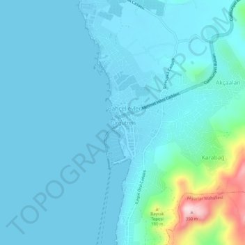
Name: Turgutreis topographic map, elevation, terrain.
Location: Turgutreis, Bodrum, Muğla, Aegean Region, 48960, Turkey (36.98577 27.23783 37.02577 27.27783)
Average elevation: 40 m
Minimum elevation: -2 m
Maximum elevation: 352 m
Thank you for supporting this site ❤️
Make a donation
Make a donation
Gear up for your next adventure:
As an Amazon Associate, this site earns from qualifying purchases at no extra cost to you.