Geolocate

Apsley topographic map

Click on the map to display elevation.

About this map

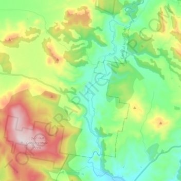
Name: Apsley topographic map, elevation, terrain.

Location: Apsley, Central Highlands, Tasmania, Australia (-42.45976 147.06666 -42.35587 147.22850)

Average elevation: 417 m

Minimum elevation: 188 m

Maximum elevation: 859 m

Other topographic maps

Click on a map to view its topography, its elevation and its terrain.

Frog Hill

Australia > Tasmania

Average elevation: 875 m

Mount Kate

Australia > Tasmania

Average elevation: 995 m

Tasman Peninsula

Australia > Tasmania > Tasman > Fortescue

Average elevation: 167 m

Mount Jukes

Australia > Tasmania

Average elevation: 773 m

Ulverstone

Australia > Tasmania > Ulverstone

Average elevation: 37 m

Bullock Hill

Australia > Tasmania > Grove

Average elevation: 147 m

Highland Waters

Australia > Tasmania > London Lakes

Average elevation: 759 m

Stillwater Hill

Australia > Tasmania

Average elevation: 353 m

Legges Tor

Australia > Tasmania

Average elevation: 1,457 m

Rowlands Hill

Australia > Tasmania

Average elevation: 388 m

Recherche Bay

Australia > Tasmania

Average elevation: 10 m

Bastyan Dam

Australia > Tasmania > Tullah

Average elevation: 233 m

Gear up for your next adventure:

🧰Survival Kit - Essential gear for emergencies in the wilderness
💡Portable Camping Lamp - Rechargeable lamp for campsite lighting
🔪Outdoor Multitool - Versatile tool for repairs and food prep in the wild
🥾All-Terrain Hiking Boots - Versatile boots for varied hiking conditions
🧥Fleece Jacket - Warm and lightweight jacket for layering

As an Amazon Associate, this site earns from qualifying purchases at no extra cost to you.