
Make a donation
Gear up for your next adventure:
As an Amazon Associate, this site earns from qualifying purchases at no extra cost to you.
Sesquilé topographic map
Click on the map to display elevation.
Make a donation
Gear up for your next adventure:
As an Amazon Associate, this site earns from qualifying purchases at no extra cost to you.
Sesquilé
La altitud media del municipio es de 2595 m s. n. m., y su temperatura media anual es de 14.1 °C, con abundantes lluvias durante el año. Sesquilé limita al sur con Guatavita; al norte con Chocontá y Suesca; al oriente con Machetá, y al occidente con Gachancipá.
Make a donation
Gear up for your next adventure:
As an Amazon Associate, this site earns from qualifying purchases at no extra cost to you.
About this map
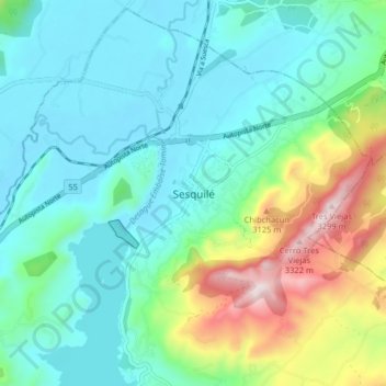
Name: Sesquilé topographic map, elevation, terrain.
Location: Sesquilé, Almeidas, Cundinamarca, Colombia (5.00462 -73.83639 5.08462 -73.75639)
Average elevation: 2,737 m
Minimum elevation: 2,553 m
Maximum elevation: 3,317 m
Make a donation
Gear up for your next adventure:
As an Amazon Associate, this site earns from qualifying purchases at no extra cost to you.