
Town of Patterson topographic map
Interactive map
Click on the map to display elevation.
About this map
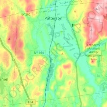
Name: Town of Patterson topographic map, elevation, terrain.
Average elevation: 202 m
Minimum elevation: 95 m
Maximum elevation: 383 m
Other topographic maps
Click on a map to view its topography, its elevation and its terrain.
Oscawana Corners
United States > New York > Putnam County > Town of Putnam Valley
Oscawana Corners, Town of Putnam Valley, Putnam County, New York, 10579, United States
Average elevation: 158 m
Gilbert Corners
United States > New York > Putnam County > Town of Putnam Valley
Gilbert Corners, Town of Putnam Valley, Putnam County, New York, 10579, United States
Average elevation: 193 m
Town of Putnam Valley
United States > New York > Putnam County
Town of Putnam Valley, Putnam County, New York, United States
Average elevation: 194 m
Lake Carmel
United States > New York > Putnam County
Lake Carmel, Town of Kent, Putnam County, New York, 10512, United States
Average elevation: 221 m