Geolocate

Welch topographic map

Click on the map to display elevation.

About this map

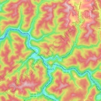
Name: Welch topographic map, elevation, terrain.

Location: Welch, McDowell County, West Virginia, 24801, United States (37.41142 -81.61122 37.47960 -81.53677)

Average elevation: 548 m

Minimum elevation: 373 m

Maximum elevation: 689 m

Other topographic maps

Click on a map to view its topography, its elevation and its terrain.

Vivian

United States > West Virginia > McDowell County

Average elevation: 619 m

Gear up for your next adventure:

🪑Insulated Seat Pad - Protect your seat from cold rocks and wet logs
🥾Trekking Poles - Adjustable trekking poles to reduce knee stress and improve stability
🧥Ultralight Puffy Jacket - Maximum warmth that packs down to the size of an orange
🔭Compact Monocular - One-handed bird watching and trail spotting
🧳Compression Sacks - Maximize space in your backpack by shrinking gear

As an Amazon Associate, this site earns from qualifying purchases at no extra cost to you.