Geolocate

Tauramena topographic map

Click on the map to display elevation.

About this map

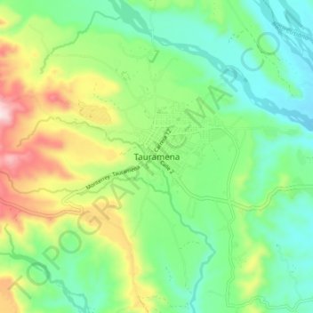
Name: Tauramena topographic map, elevation, terrain.

Location: Tauramena, Casanare, Colombia (4.97341 -72.79071 5.05341 -72.71071)

Average elevation: 457 m

Minimum elevation: 325 m

Maximum elevation: 724 m

Gear up for your next adventure:

🚲Bike Repair Kit - Essential tools for on-trail mechanical issues
🧥Packable Rain Jacket - Breathable waterproof layer for unpredictable weather
🥾Mountain Hiking Shoes - Shoes with superior grip for mountainous terrain
🧭GPS Handheld Device - Reliable GPS navigation for outdoor adventures
🥾Lightweight Hiking Shoes - Comfortable shoes for day hikes

As an Amazon Associate, this site earns from qualifying purchases at no extra cost to you.