Geolocate

Pallua Sur topographic map

Click on the map to display elevation.

About this map
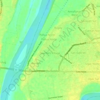
Name: Pallua Sur topographic map, elevation, terrain.

Location: Pallua Sur, Tuguegarao, Cagayan, Cagayan Valley, 3500, Philippines (17.60201 121.68237 17.64201 121.72237)

Average elevation: 22 m

Minimum elevation: 10 m

Maximum elevation: 31 m

Other topographic maps

Click on a map to view its topography, its elevation and its terrain.

Centro XII

Philippines > Cagayan > Tuguegarao > Balzain West

Average elevation: 25 m

Centro V

Philippines > Cagayan > Tuguegarao

Average elevation: 22 m

Pinancauanan River

Philippines > Cagayan > Tuguegarao > Capatan

Average elevation: 102 m

Centro X

Philippines > Cagayan > Tuguegarao > Capatan

Average elevation: 22 m

Centro IX

Philippines > Cagayan > Tuguegarao

Average elevation: 21 m

Gear up for your next adventure:

🧥Ultralight Puffy Jacket - Maximum warmth that packs down to the size of an orange
🧦Hiking Socks - Moisture-wicking and comfortable socks for long hikes
💧Filtered Water Bottle - Safe drinking water on the go
🧢Hiking Hat - Sun-protective and breathable hats for long treks
🧥Softshell Hiking Jacket - The perfect balance of wind protection and breathability

As an Amazon Associate, this site earns from qualifying purchases at no extra cost to you.