Geolocate

Cazadero topographic map

Click on the map to display elevation.

About this map

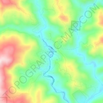
Name: Cazadero topographic map, elevation, terrain.

Location: Cazadero, Sonoma County, California, 95421, United States (38.51341 -123.10546 38.55341 -123.06546)

Average elevation: 173 m

Minimum elevation: 23 m

Maximum elevation: 420 m

Other topographic maps

Click on a map to view its topography, its elevation and its terrain.

Windsor

United States > California > Sonoma County

Average elevation: 39 m

Bodega Bay

United States > California > Sonoma County

Average elevation: 59 m

Healdsburg

United States > California > Sonoma County

Average elevation: 45 m

Sebastopol

United States > California > Sonoma County > Sebastopol

Sebastopol's elevation is 65 to 250 feet (20 to 76 meters) above sea level. Its downtown is at the intersection of State Route 12 and State Route 116 (Gravenstein Highway), approximately 9 mi (14 km) west of U.S. Route 101.

Average elevation: 43 m

Petaluma

United States > California > Sonoma County

Average elevation: 131 m

Gear up for your next adventure:

🥾Trekking Boots - Durable boots for long-distance trekking
Camping Essentials - All-in-one gear for a comfortable camping trip
🧦Hiking Liner Socks - Thin base layer to prevent friction and blisters
Lightweight Backpacking Tent - Compact tent for efficient hiking trips
🧦Crew Hiking Socks - Comfortable socks for long-distance hikes

As an Amazon Associate, this site earns from qualifying purchases at no extra cost to you.