
Make a donation
Gear up for your next adventure:
As an Amazon Associate, this site earns from qualifying purchases at no extra cost to you.
Somport topographic map
Click on the map to display elevation.
Make a donation
Gear up for your next adventure:
As an Amazon Associate, this site earns from qualifying purchases at no extra cost to you.
Somport
De Col du Somport is een col in de Pyreneeën op de Spaans-Franse grens op 1632 meter hoogte. Er kan op die hoogte sneeuw liggen van eind oktober tot eind mei. De pas is echter zelden gesloten.
Make a donation
Gear up for your next adventure:
As an Amazon Associate, this site earns from qualifying purchases at no extra cost to you.
About this map
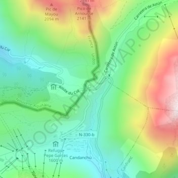
Name: Somport topographic map, elevation, terrain.
Location: Somport, Aísa, La Jacetania, Huesca, Aragón, 22889, Spanje (42.79567 -0.52490 42.79577 -0.52480)
Average elevation: 1,727 m
Minimum elevation: 1,449 m
Maximum elevation: 2,243 m
Make a donation
Gear up for your next adventure:
As an Amazon Associate, this site earns from qualifying purchases at no extra cost to you.