Dover topographic map
Click on the map to display elevation.
Dover
The mild hills historically supported oak-hickory forest or oak-hickory-pine forest. Elevation changes and soil types make the Arkansas Valley Hills largely unsuitable for row agriculture. Instead, forest has been cleared for pastureland, poultry farming or ranching. Logging remains an important land use where elevation or soil makes livestock farming unsuitable. Many of the smaller streams and watercourses are completely dry in summer.
About this map
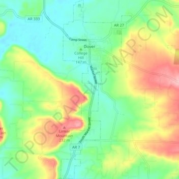
Name: Dover topographic map, elevation, terrain.
Location: Dover, Pope County, Arkansas, 72837, United States (35.35115 -93.12742 35.41773 -93.09518)
Average elevation: 164 m
Minimum elevation: 113 m
Maximum elevation: 252 m
Other topographic maps
Click on a map to view its topography, its elevation and its terrain.