Geolocate

Paradise topographic map

Click on the map to display elevation.

Paradise

The town is spread out on a wide ridge between deep canyons formed by the west branch of the Feather River to the east and Butte Creek to the west. The Paradise area extends northward to include the unincorporated town of Magalia, as well as Stirling City, eleven miles (18 km) north. Elevation of the area where the town is located is 1,778 feet (542 m). The town itself is approximately eight miles (13 km) east of the city of Chico, and ten miles (16 km) north of the Oroville area.

Wikipedia (CC-BY-SA 3.0)

About this map

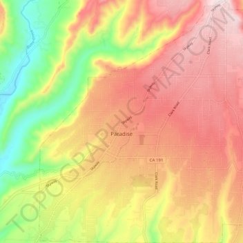
Name: Paradise topographic map, elevation, terrain.

Location: Paradise, Butte County, California, 95969, United States (39.72536 -121.65565 39.80154 -121.56445)

Average elevation: 464 m

Minimum elevation: 139 m

Maximum elevation: 726 m

Other topographic maps

Click on a map to view its topography, its elevation and its terrain.

Cohasset

United States > California > Butte County

Average elevation: 777 m

Wyandotte

United States > California > Butte County

Average elevation: 203 m

Hurleton

United States > California > Butte County

Average elevation: 531 m

Stirling City

United States > California > Butte County

Stirling City is a census-designated place in Butte County, California, located on Paradise Ridge in the western foothills of the Sierra Nevada. Contrary to its name, Stirling City is not a city. Its ZIP Code is 95978 and area code 530. It lies at an elevation of 3570 feet (1088 m). Stirling City had a…

Average elevation: 1,044 m

Sky High

United States > California > Butte County

Average elevation: 966 m

Clipper Mills

United States > California > Butte County

Average elevation: 1,060 m

Inskip

United States > California > Butte County

Average elevation: 1,378 m

Magalia

United States > California > Butte County

Average elevation: 695 m

Barber

United States > California > Butte County > Chico

Average elevation: 59 m

Forest Ranch

United States > California > Butte County

Average elevation: 672 m

Cherokee

United States > California > Butte County

Average elevation: 359 m

Palermo

United States > California > Butte County

Average elevation: 60 m

Magalia

United States > California > Butte County

Average elevation: 624 m

Big Bend

United States > California > Butte County

Average elevation: 574 m

Berry Creek

United States > California > Butte County

Average elevation: 697 m

Butte Meadows

United States > California > Butte County

Average elevation: 1,379 m

Paradise Dam

United States > California > Butte County

Average elevation: 789 m

Merrimac

United States > California > Butte County

Average elevation: 1,191 m

Paradise Pines

United States > California > Butte County

Average elevation: 724 m

Pulga

United States > California > Butte County

Average elevation: 750 m

Peachton

United States > California > Butte County

Average elevation: 30 m

Gear up for your next adventure:

🔦LED Headtorch - Bright and durable light for night activities
🪜Heavy Duty Carabiners - Multi-use clips for securing gear to your backpack
🥾Approach Boots - Comfortable boots for hiking and climbing approaches
Backpacking Tent - Lightweight tent for long-distance hiking trips
🧥Waterproof Pants - Keep dry during rainy hiking conditions

As an Amazon Associate, this site earns from qualifying purchases at no extra cost to you.