
Bowman County topographic map
Interactive map
Click on the map to display elevation.
About this map
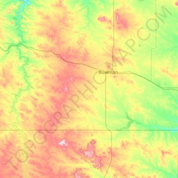
Name: Bowman County topographic map, elevation, terrain.
Location: Bowman County, North Dakota, United States (45.94513 -104.04682 46.28070 -102.99553)
Average elevation: 899 m
Minimum elevation: 791 m
Maximum elevation: 1,099 m
Other topographic maps
Click on a map to view its topography, its elevation and its terrain.
White Butte
United States > North Dakota > Slope County
White Butte is the highest natural point in the U.S. state of North Dakota. At an elevation of 3,506 ft (1,069 m), it is a prominent butte in Slope County, in the Badlands of the southwestern part of the state. It is located 3 miles (5 kilometers) east of U.S. 85 and about 6.5 mi (10 km) south of Amidon.
Average elevation: 974 m