Geolocate

Tiffin topographic map

Click on the map to display elevation.

About this map
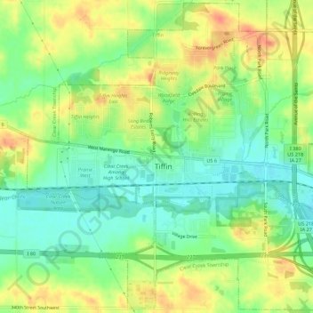
Name: Tiffin topographic map, elevation, terrain.

Location: Tiffin, Johnson County, Iowa, 52340, United States (41.68698 -91.69093 41.72716 -91.63419)

Average elevation: 227 m

Minimum elevation: 204 m

Maximum elevation: 254 m

Other topographic maps

Click on a map to view its topography, its elevation and its terrain.
Cosgrove

United States > Iowa > Johnson County

Average elevation: 228 m

Cosgrove

United States > Iowa > Johnson County

Average elevation: 228 m

Gear up for your next adventure:

👟Leg Gaiters - Keep debris, mud, and snow out of your boots
🧥Softshell Jacket - Windproof and breathable jacket for hiking
🔋Emergency Crank Radio - Weather alerts and power without needing batteries
💧Hydration Bladder - Hands-free hydration solution for long treks
🎒Hiking Daypack - Lightweight and durable backpacks for day trips and excursions

As an Amazon Associate, this site earns from qualifying purchases at no extra cost to you.