Geolocate

Santa Juana topographic map

Click on the map to display elevation.

About this map

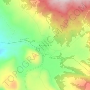
Name: Santa Juana topographic map, elevation, terrain.

Location: Santa Juana, Pátzcuaro, Michoacán, Mexico (19.41045 -101.58082 19.45045 -101.54082)

Average elevation: 2,557 m

Minimum elevation: 2,315 m

Maximum elevation: 2,837 m

Gear up for your next adventure:

🧢Sun Protection Cap - Breathable cap to protect from sun exposure
🔭Compact Monocular - One-handed bird watching and trail spotting
👟Leg Gaiters - Keep debris, mud, and snow out of your boots
🥾Durable Hiking Shoes - Long-lasting shoes for frequent hiking
🚑Survival Whistle - Signal for help across long distances in mountains

As an Amazon Associate, this site earns from qualifying purchases at no extra cost to you.