
Verden topographic map
Interactive map
Click on the map to display elevation.
About this map
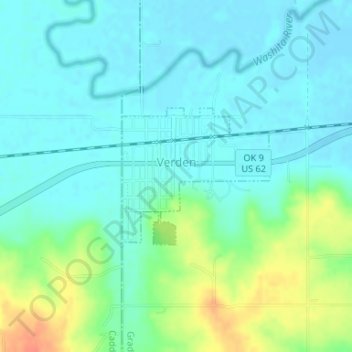
Name: Verden topographic map, elevation, terrain.
Location: Verden, Grady County, Oklahoma, 73092, United States (35.07703 -98.09294 35.08753 -98.07907)
Average elevation: 356 m
Minimum elevation: 343 m
Maximum elevation: 390 m
Other topographic maps
Click on a map to view its topography, its elevation and its terrain.
Rush Springs
United States > Oklahoma > Grady County
Rush Springs, Grady County, Oklahoma, 73082, United States
Average elevation: 409 m
Bridge Creek
United States > Oklahoma > Grady County
Bridge Creek, Grady County, Oklahoma, United States
Average elevation: 411 m
Cox City
United States > Oklahoma > Grady County
Cox City, Grady County, Oklahoma, United States
Average elevation: 360 m
Amber
United States > Oklahoma > Grady County
Amber, Grady County, Oklahoma, 73004, United States
Average elevation: 376 m
Alex
United States > Oklahoma > Grady County
Alex, Grady County, Oklahoma, United States
Average elevation: 323 m
Norge
United States > Oklahoma > Grady County
Norge, Grady County, Oklahoma, United States
Average elevation: 380 m
Ninnekah
United States > Oklahoma > Grady County
Ninnekah, Grady County, Oklahoma, 73067, United States
Average elevation: 347 m
Bradley
United States > Oklahoma > Grady County
Bradley, Grady County, Oklahoma, United States
Average elevation: 317 m
Minco
United States > Oklahoma > Grady County
Minco, Grady County, Oklahoma, 73059, United States
Average elevation: 395 m
Chickasha
United States > Oklahoma > Grady County
Chickasha, Grady County, Oklahoma, 73018, United States
Average elevation: 350 m
Tuttle
United States > Oklahoma > Grady County
Tuttle, Grady County, Oklahoma, 73089, United States
Average elevation: 391 m
Pocasset
United States > Oklahoma > Grady County
Pocasset, Grady County, Oklahoma, United States
Average elevation: 359 m