
Make a donation
Gear up for your next adventure:
As an Amazon Associate, this site earns from qualifying purchases at no extra cost to you.
Cosa topographic map
Click on the map to display elevation.
Make a donation
Gear up for your next adventure:
As an Amazon Associate, this site earns from qualifying purchases at no extra cost to you.
Cosa
El relieve del territorio está caracterizado por el Sistema Ibérico turolense, al este de la depresión que forma el río Jiloca. Se encuentra a gran altitud, la cual oscila entre los 1385 metros al suroeste, en la llamada Loma Pedriza, y los 1130 metros al noroeste, a orillas del río de Cosa. El pueblo se alza a 1185 metros sobre el nivel del mar.
Make a donation
Gear up for your next adventure:
As an Amazon Associate, this site earns from qualifying purchases at no extra cost to you.
About this map
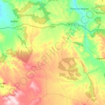
Name: Cosa topographic map, elevation, terrain.
Location: Cosa, Jiloca, Teruel, Aragón, España (40.74850 -1.17315 40.86252 -1.07132)
Average elevation: 1,248 m
Minimum elevation: 1,045 m
Maximum elevation: 1,493 m
Make a donation
Gear up for your next adventure:
As an Amazon Associate, this site earns from qualifying purchases at no extra cost to you.
Other topographic maps
Click on a map to view its topography, its elevation and its terrain.