Geolocate

Payne topographic map

Click on the map to display elevation.

About this map

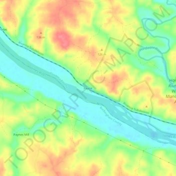
Name: Payne topographic map, elevation, terrain.

Location: Payne, Fluvanna County, Virginia, United States (37.73264 -78.46223 37.77264 -78.42223)

Average elevation: 106 m

Minimum elevation: 73 m

Maximum elevation: 144 m

Other topographic maps

Click on a map to view its topography, its elevation and its terrain.

Columbia

United States > Virginia > Fluvanna County

Average elevation: 78 m

Gear up for your next adventure:

🧢Outdoor Visor - Breathable visor for sunny hikes
🪑Insulated Seat Pad - Protect your seat from cold rocks and wet logs
🧦Crew Hiking Socks - Comfortable socks for long-distance hikes
🧥Insulated Jacket - Keep warm in cold outdoor conditions
🧊Insulated Water Bottle - Keeps drinks cold in summer and prevents freezing in winter

As an Amazon Associate, this site earns from qualifying purchases at no extra cost to you.