
Make a donation
Gear up for your next adventure:
As an Amazon Associate, this site earns from qualifying purchases at no extra cost to you.
Bad Liebenwerda topographic map
Click on the map to display elevation.
Make a donation
Gear up for your next adventure:
As an Amazon Associate, this site earns from qualifying purchases at no extra cost to you.
Bad Liebenwerda
Die folgenden Jahre waren von Reformen geprägt. Die Mehrzahl der Betriebe ging in Volkseigentum über. Ihr Anteil betrug 1955 bereits 78 Prozent. Nach der 1945 einsetzenden Bodenreform kam es nun zu Gründungen von Landwirtschaftlichen Produktionsgenossenschaften. Das Eisenmoorbad der Stadt, das bereits 1946 wieder 26.505 Behandlungen verzeichnen konnte, wurde 1955 von der Sozialversicherung des FDGB übernommen. Die Festwoche 650 Jahre Stadtrecht fand vom 28. Mai bis zum 5. Juni 1954 statt. Höhepunkte des Heimatfestes waren ein großer Festumzug unter dem Motto Liebenwerda vom Mittelalter bis zur Gegenwart und ein abschließendes Feuerwerk am Elsterdamm.
Make a donation
Gear up for your next adventure:
As an Amazon Associate, this site earns from qualifying purchases at no extra cost to you.
About this map
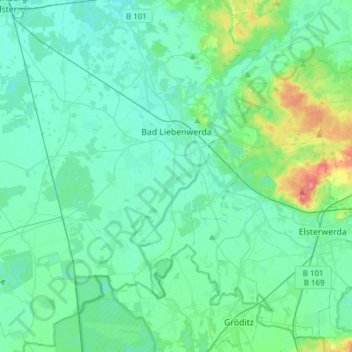
Name: Bad Liebenwerda topographic map, elevation, terrain.
Average elevation: 94 m
Minimum elevation: 82 m
Maximum elevation: 154 m
Make a donation
Gear up for your next adventure:
As an Amazon Associate, this site earns from qualifying purchases at no extra cost to you.
Other topographic maps
Click on a map to view its topography, its elevation and its terrain.
Prestewitz
Deutschland > Brandenburg > Elbe-Elster
Hanssenn Holleufer wurde in einem Lehnsbrief vom 8. Juli 1548 durch Herzog Moritz Prestewitz verliehen, und 1555 verzeichnete der Ort 14 Hufner sowie 3 Gärtner. Im Jahr 1558 verkaufte Friedrich von Holda die sogenannten Dritthalbdörfer Beutersitz, Theisa und Prestewitz an Siegmund von Brandenstein, welcher…
Average elevation: 94 m