
Make a donation
Gear up for your next adventure:
As an Amazon Associate, this site earns from qualifying purchases at no extra cost to you.
Würzburg topographic map
Click on the map to display elevation.
Make a donation
Gear up for your next adventure:
As an Amazon Associate, this site earns from qualifying purchases at no extra cost to you.
Würzburg
Würzburg covers an area of 87.6 square kilometres and lies at an altitude of around 177 metres.
Make a donation
Gear up for your next adventure:
As an Amazon Associate, this site earns from qualifying purchases at no extra cost to you.
About this map
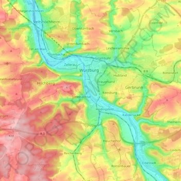
Name: Würzburg topographic map, elevation, terrain.
Location: Würzburg, Bavaria, Germany (49.71068 9.87163 49.84546 10.01443)
Average elevation: 270 m
Minimum elevation: 166 m
Maximum elevation: 385 m
Make a donation
Gear up for your next adventure:
As an Amazon Associate, this site earns from qualifying purchases at no extra cost to you.
Other topographic maps
Click on a map to view its topography, its elevation and its terrain.
Kogelberg
Germany > Bavaria > Landkreis Bad Tölz-Wolfratshausen > Lenggries
Average elevation: 1,020 m