
Thank you for supporting this site ❤️
Make a donation
Make a donation
Gear up for your next adventure:
As an Amazon Associate, this site earns from qualifying purchases at no extra cost to you.
Despotovac topographic map
Click on the map to display elevation.
Thank you for supporting this site ❤️
Make a donation
Make a donation
Gear up for your next adventure:
As an Amazon Associate, this site earns from qualifying purchases at no extra cost to you.
About this map
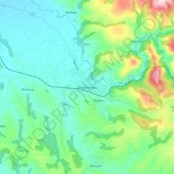
Name: Despotovac topographic map, elevation, terrain.
Average elevation: 259 m
Minimum elevation: 156 m
Maximum elevation: 566 m
Thank you for supporting this site ❤️
Make a donation
Make a donation
Gear up for your next adventure:
As an Amazon Associate, this site earns from qualifying purchases at no extra cost to you.
Other topographic maps
Click on a map to view its topography, its elevation and its terrain.
Lipovica
Serbia > Central Serbia > Pomoravlje Administrative District > Despotovac Municipality
Lipovica is located along the state road 186. Its average elevation is 449 meters above the sea level.
Average elevation: 449 m