
Newton topographic map
Interactive map
Click on the map to display elevation.
About this map
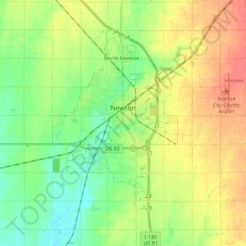
Name: Newton topographic map, elevation, terrain.
Location: Newton, Harvey County, Kansas, United States (37.99195 -97.46842 38.08626 -97.30924)
Average elevation: 446 m
Minimum elevation: 425 m
Maximum elevation: 471 m
Other topographic maps
Click on a map to view its topography, its elevation and its terrain.
Sedgwick
United States > Kansas > Harvey County
Sedgwick, Harvey County, Kansas, United States
Average elevation: 421 m
Hesston
United States > Kansas > Harvey County
Hesston, Harvey County, Kansas, 67062, United States
Average elevation: 450 m
Burrton
United States > Kansas > Harvey County
Burrton, Harvey County, Kansas, United States
Average elevation: 443 m