Geolocate

Muara Limun topographic map

Click on the map to display elevation.

About this map

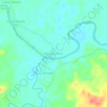
Name: Muara Limun topographic map, elevation, terrain.

Location: Muara Limun, Sarolangun, Jambi, Sumatra, Indonesia (-2.41932 102.62591 -2.37932 102.66591)

Average elevation: 54 m

Minimum elevation: 40 m

Maximum elevation: 97 m

Other topographic maps

Click on a map to view its topography, its elevation and its terrain.

Batang Asai

Indonesia > Jambi > Sarolangun

Average elevation: 365 m

Gear up for your next adventure:

🔦LED Headlamp - Hands-free lighting for early morning starts or late finishes
💡Portable Camping Lamp - Rechargeable lamp for campsite lighting
🎒Hiking Daypack - Lightweight and durable backpacks for day trips and excursions
💡LED Headlamp - Hands-free illumination for night hiking and camping
🛰️Satellite Messenger - Emergency communication for areas with no cell service

As an Amazon Associate, this site earns from qualifying purchases at no extra cost to you.