Geolocate

Sooko topographic map

Click on the map to display elevation.

About this map

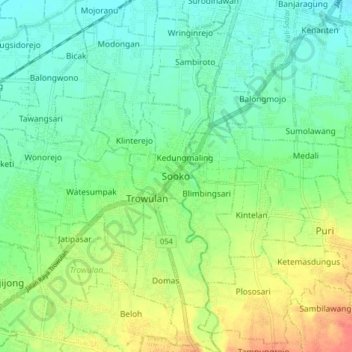
Name: Sooko topographic map, elevation, terrain.

Location: Sooko, Gemekan, Mojokerto, East Java, Java, 61363, Indonesia (-7.56765 112.37196 -7.48765 112.45196)

Average elevation: 39 m

Minimum elevation: 21 m

Maximum elevation: 72 m

Gear up for your next adventure:

💧Reusable Water Bottle - Durable water bottles for hydration on trails
Family Camping Tent - Spacious tent suitable for family camping trips
🧴First Aid Kit - Essential first aid supplies for outdoor emergencies
🚲MTB Frame Bag - Carry tools and maps directly on your bicycle frame
Camping Groundsheet - Protect your tent from moisture and dirt

As an Amazon Associate, this site earns from qualifying purchases at no extra cost to you.