
Methuen topographic map
Click on the map to display elevation.
About this map
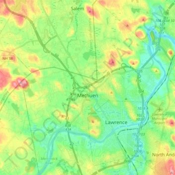
Name: Methuen topographic map, elevation, terrain.
Location: Methuen, Essex County, Massachusetts, 01844, United States (42.66942 -71.25513 42.79433 -71.11556)
Average elevation: 42 m
Minimum elevation: -1 m
Maximum elevation: 121 m
Other topographic maps
Click on a map to view its topography, its elevation and its terrain.
Williams Conservation Land
United States > Massachusetts > Essex County > Wenham
Average elevation: 23 m
Rockaway Conservation Area
United States > Massachusetts > Essex County > Peabody
Average elevation: 36 m
Haverhill
United States > Massachusetts > Essex County > Haverhill
According to the United States Census Bureau, the city has a total area of 35.6 square miles (92.3 km2), of which 33.0 square miles (85.4 km2) is land and 2.7 square miles (6.9 km2), or 7.47%, is water. The city ranks 60th in the Commonwealth in terms of land area, and is the largest city or town in Essex…
Average elevation: 45 m
Annisquam
United States > Massachusetts > Essex County > Gloucester > Annisquam
Average elevation: 14 m