Geolocate

Chigugu topographic map

Click on the map to display elevation.

About this map

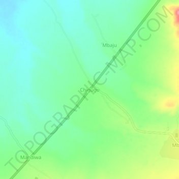
Name: Chigugu topographic map, elevation, terrain.

Location: Chigugu, Masasi, Mtwara Region, Coastal Zone, Tanzania (-10.57869 38.91262 -10.53869 38.95262)

Average elevation: 314 m

Minimum elevation: 284 m

Maximum elevation: 378 m

Other topographic maps

Click on a map to view its topography, its elevation and its terrain.

Tandahimba

Tanzania > Mtwara Region

Average elevation: 333 m

Masasi

Tanzania > Mtwara Region

Average elevation: 345 m

Gear up for your next adventure:

🧳Compression Sacks - Maximize space in your backpack by shrinking gear
🧊Portable Cooler - Keep food and drinks cold during outdoor adventures
🔦LED Flashlight - Powerful and long-lasting flashlight for camping and emergencies
🥾Trekking Poles - Adjustable trekking poles to reduce knee stress and improve stability
🥾Trail Hiking Boots - Supportive boots for rough trails

As an Amazon Associate, this site earns from qualifying purchases at no extra cost to you.