Geolocate

Monte Agner topographic map

Click on the map to display elevation.

About this map

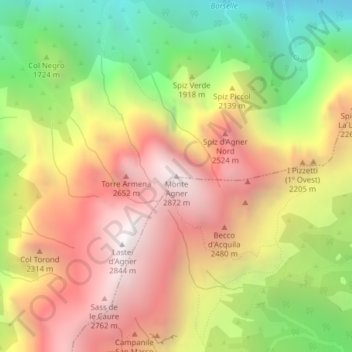
Name: Monte Agner topographic map, elevation, terrain.

Location: Monte Agner, Taibon Agordino, Belluno, Veneto, 32027, Italy (46.27636 11.95266 46.27646 11.95276)

Average elevation: 1,887 m

Minimum elevation: 855 m

Maximum elevation: 2,830 m

Gear up for your next adventure:

🥾Lightweight Hiking Shoes - Comfortable shoes for day hikes
🥾Durable Hiking Shoes - Long-lasting shoes for frequent hiking
🩹Moleskin Blister Pads - Direct protection for painful foot pressure points
🥾Light Trekking Boots - Supportive boots for multi-day treks
Tent Footprint - Protect tent floor and increase durability

As an Amazon Associate, this site earns from qualifying purchases at no extra cost to you.