Geolocate

Junior topographic map

Click on the map to display elevation.

About this map

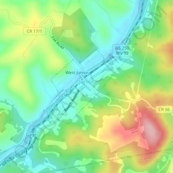
Name: Junior topographic map, elevation, terrain.

Location: Junior, Barbour County, West Virginia, 26275, United States (38.97203 -79.95768 38.98372 -79.94141)

Average elevation: 587 m

Minimum elevation: 520 m

Maximum elevation: 700 m

Other topographic maps

Click on a map to view its topography, its elevation and its terrain.

Audra

United States > West Virginia > Barbour County

Average elevation: 572 m

Gear up for your next adventure:

🧥Packable Rain Jacket - Breathable waterproof layer for unpredictable weather
🎒Fully Waterproof Backpack - Total protection for photography gear and electronics
🥾Hiking Shoes - Durable and comfortable shoes for trail hiking
🥾Waterproof Trail Shoes - Shoes designed to handle wet terrain
🧴Sunscreen SPF - Broad-spectrum sunscreen for outdoor activities

As an Amazon Associate, this site earns from qualifying purchases at no extra cost to you.