Geolocate

Baishou topographic map

Click on the map to display elevation.

About this map

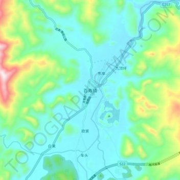
Name: Baishou topographic map, elevation, terrain.

Location: Baishou, Guilin, Guangxi, China (25.12177 109.72988 25.20177 109.80988)

Average elevation: 352 m

Minimum elevation: 199 m

Maximum elevation: 872 m

Other topographic maps

Click on a map to view its topography, its elevation and its terrain.

Pingle County

China > Guangxi > Guilin

Average elevation: 390 m

Xiangshan District

China > Guangxi > Guilin

Average elevation: 179 m

Yangshuo County

China > Guangxi > Guilin

Average elevation: 319 m

Yangshuo County

China > Guangxi > Guilin

Average elevation: 319 m

Gear up for your next adventure:

🧢Beanie Hat - Keep your head warm in cold weather
🥾Waterproof Hiking Shoes - Durable shoes for wet and rugged trails
🥾Trekking Poles - Adjustable trekking poles to reduce knee stress and improve stability
Backpacking Tent - Lightweight tent for long-distance hiking trips
🔪Outdoor Multitool - Versatile tool for repairs and food prep in the wild

As an Amazon Associate, this site earns from qualifying purchases at no extra cost to you.