Geolocate

Mancatian topographic map

Click on the map to display elevation.

About this map

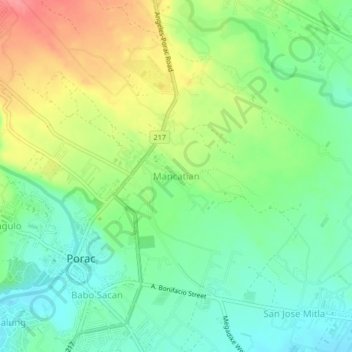
Name: Mancatian topographic map, elevation, terrain.

Location: Mancatian, Porac, Pampanga, Central Luzon, 2008, Philippines (15.06200 120.53425 15.10200 120.57425)

Average elevation: 93 m

Minimum elevation: 61 m

Maximum elevation: 142 m

Other topographic maps

Click on a map to view its topography, its elevation and its terrain.

Miyamit Falls

Philippines > Pampanga > Porac

Average elevation: 807 m

Barangay Dolores Plaza

Philippines > Pampanga > Porac

Average elevation: 133 m

Gear up for your next adventure:

🧊Portable Cooler - Keep food and drinks cold during outdoor adventures
🔥Camping Stove - Portable stoves to cook outdoors with ease
🥘Camping Cookware Set - Compact nesting pots and pans for trail cooking
🏕️Camping Hammock - Integrated protection for sleeping between trees
🧢Beanie Hat - Keep your head warm in cold weather

As an Amazon Associate, this site earns from qualifying purchases at no extra cost to you.