Geolocate

Markkleeberg topographic map

Click on the map to display elevation.

About this map

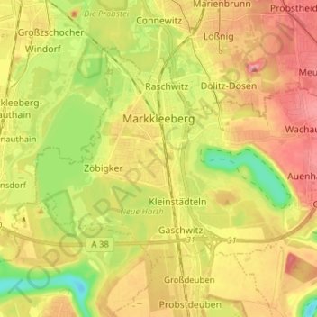
Name: Markkleeberg topographic map, elevation, terrain.

Location: Markkleeberg, Landkreis Leipzig, Saxony, 04416, Germany (51.24044 12.32221 51.29647 12.44929)

Average elevation: 121 m

Minimum elevation: 71 m

Maximum elevation: 163 m

Other topographic maps

Click on a map to view its topography, its elevation and its terrain.

Oellschütz

Germany > Saxony > Landkreis Leipzig > Groitzsch > Hohendorf

Average elevation: 138 m

Gear up for your next adventure:

Family Camping Tent - Spacious tent suitable for family camping trips
🎒Hiking Backpack - Lightweight and ergonomic backpacks for day hikes or multi-day treks
Lightweight Backpacking Tent - Compact tent for efficient hiking trips
🧭GPS Outdoor Watch - Smart watch for navigation and fitness tracking in nature
🧣Evaporative Cooling Towel - Beat the heat during intense summer climbs

As an Amazon Associate, this site earns from qualifying purchases at no extra cost to you.