Geolocate

Grottammare topographic map

Click on the map to display elevation.

About this map

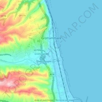
Name: Grottammare topographic map, elevation, terrain.

Location: Grottammare, Ascoli Piceno, Marche, Italy (42.95721 13.81515 43.01005 13.88198)

Average elevation: 55 m

Minimum elevation: -1 m

Maximum elevation: 255 m

Other topographic maps

Click on a map to view its topography, its elevation and its terrain.

Petrella

Italy > Marche > Ascoli Piceno > Ripatransone

Average elevation: 241 m

Magazzini

Italy > Marche > Ascoli Piceno > Ripatransone

Average elevation: 147 m

Ponte Tesino

Italy > Marche > Ascoli Piceno > Cossignano

Average elevation: 250 m

San Martino

Italy > Marche > Ascoli Piceno > Castignano

Average elevation: 389 m

Monte Sibilla

Italy > Marche > Ascoli Piceno > Montemonaco

Average elevation: 1,641 m

Gear up for your next adventure:

🥾Trekking Poles - Adjustable trekking poles to reduce knee stress and improve stability
🔋Solar Power Bank - Keep your GPS and devices charged during long outdoor trips
🧶550 Survival Paracord - Versatile utility cord for emergency repairs and rigging
🛁Quick-Dry Microfiber Towel - Space-saving towel that dries rapidly on the move
Backpacking Tent - Lightweight tent for long-distance hiking trips

As an Amazon Associate, this site earns from qualifying purchases at no extra cost to you.