Arapahoe topographic map
Interactive map
Click on the map to display elevation.
About this map
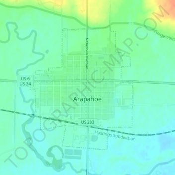
Name: Arapahoe topographic map, elevation, terrain.
Location: Arapahoe, Furnas County, Nebraska, 68922, United States (40.29556 -99.90936 40.31476 -99.88852)
Average elevation: 666 m
Minimum elevation: 654 m
Maximum elevation: 696 m
Other topographic maps
Click on a map to view its topography, its elevation and its terrain.
Oxford
United States > Nebraska > Furnas County
Oxford, Furnas County, Nebraska, 68967, United States
Average elevation: 643 m
Cambridge
United States > Nebraska > Furnas County
Cambridge, Furnas County, Nebraska, 69022, United States
Average elevation: 699 m