
Malang topographic map
Interactive map
Click on the map to display elevation.
About this map
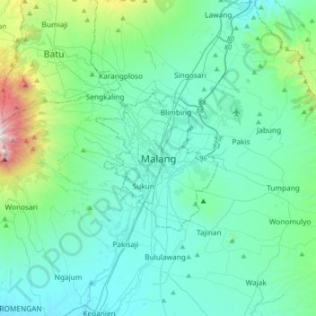
Name: Malang topographic map, elevation, terrain.
Location: Malang, Kota Malang, Jawa Timur, Jawa, Indonésie (-8.13712 112.47403 -7.81712 112.79403)
Average elevation: 657 m
Minimum elevation: 296 m
Maximum elevation: 2,740 m
Other topographic maps
Click on a map to view its topography, its elevation and its terrain.
Kota Malang
Indonésie > Jawa Timur > Kota Malang
Kota Malang, Jawa Timur, Indonésie
Average elevation: 490 m