Geolocate

Kvarn topographic map

Click on the map to display elevation.

About this map

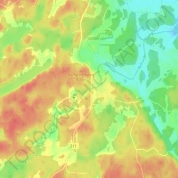
Name: Kvarn topographic map, elevation, terrain.

Location: Kvarn, Motala kommun, Östergötland County, Sweden (58.61391 15.28864 58.65391 15.32864)

Average elevation: 78 m

Minimum elevation: 52 m

Maximum elevation: 100 m

Other topographic maps

Click on a map to view its topography, its elevation and its terrain.

Kärna

Sweden > Östergötland County

Average elevation: 72 m

Gear up for your next adventure:

🛶Canoe Life Vest - Safety vest for water sports
🥾Trail Running Shoes - Lightweight and durable shoes for trail running
🧭GPS Handheld Device - Reliable GPS navigation for outdoor adventures
🧊Insulated Water Bottle - Keeps drinks cold in summer and prevents freezing in winter
🥾Mountaineering Boots - Supportive boots for climbing and high-altitude hiking

As an Amazon Associate, this site earns from qualifying purchases at no extra cost to you.