
Make a donation
Gear up for your next adventure:
As an Amazon Associate, this site earns from qualifying purchases at no extra cost to you.
Lake Mainit topographic map
Click on the map to display elevation.
Make a donation
Gear up for your next adventure:
As an Amazon Associate, this site earns from qualifying purchases at no extra cost to you.
About this map
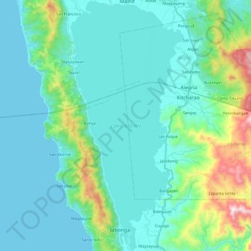
Name: Lake Mainit topographic map, elevation, terrain.
Location: Lake Mainit, Agusan del Norte, Caraga, Philippines (9.32383 125.47334 9.53847 125.57200)
Average elevation: 146 m
Minimum elevation: 0 m
Maximum elevation: 894 m
Make a donation
Gear up for your next adventure:
As an Amazon Associate, this site earns from qualifying purchases at no extra cost to you.
Other topographic maps
Click on a map to view its topography, its elevation and its terrain.
Cabadbaran
Philippines > Agusan del Norte
It is generally flat with rolling hills and swamplands in its western part. The highest of all mountains in the Caraga region, Mount Hilong-Hilong (with an altitude of 2,012 metres (6,601 ft) above sea level), rises in this city.
Average elevation: 179 m
Make a donation
Gear up for your next adventure:
As an Amazon Associate, this site earns from qualifying purchases at no extra cost to you.
Butuan
Philippines > Agusan del Norte > Butuan
Butuan is located at 8°57′N 125°32′E / 8.95°N 125.53°E / 8.95; 125.53. Elevation at these coordinates is estimated at 1.0 meter above sea level (M.a.s.l.).
Average elevation: 115 m