Geolocate

Tiawe topographic map

Click on the map to display elevation.

About this map

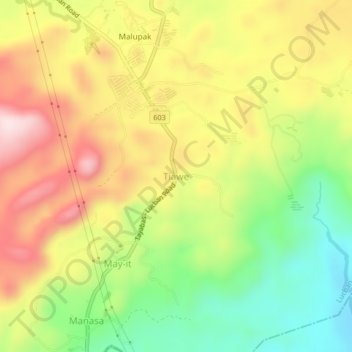
Name: Tiawe topographic map, elevation, terrain.

Location: Tiawe, Lucban, Quezon, Calabarzon, 4328, Philippines (14.06621 121.56273 14.10621 121.60273)

Average elevation: 414 m

Minimum elevation: 220 m

Maximum elevation: 615 m

Other topographic maps

Click on a map to view its topography, its elevation and its terrain.

Camatian River

Philippines > Quezon > Lucban

Average elevation: 549 m

Botocan River

Philippines > Quezon > Lucban > Kalyaat

Average elevation: 389 m

Gear up for your next adventure:

🧭GPS Outdoor Watch - Smart watch for navigation and fitness tracking in nature
🥘Camping Cookware Set - Compact nesting pots and pans for trail cooking
🦟Insect Repellent - Keep mosquitoes and black flies away in wooded areas
🔋Solar Power Bank - Keep your GPS and devices charged during long outdoor trips
🎒Fully Waterproof Backpack - Total protection for photography gear and electronics

As an Amazon Associate, this site earns from qualifying purchases at no extra cost to you.