
Irrawaddy River topographic map
Interactive map
Click on the map to display elevation.
About this map
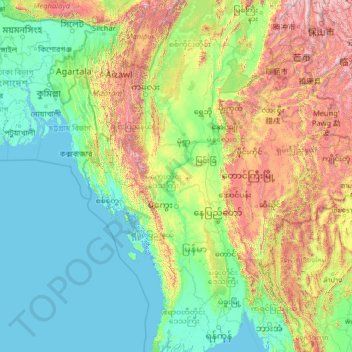
Name: Irrawaddy River topographic map, elevation, terrain.
Location: Irrawaddy River, Magway District, Magway, 10261, Myanmar (16.11399 94.68480 25.70995 97.53597)
Average elevation: 438 m
Minimum elevation: -3 m
Maximum elevation: 3,525 m
The streams of the Nmai and Mali that form the Irrawaddy originate in high and remote mountains near the border with Tibet. This part of Myanmar, which extends north from Myitkyina and the Irrawaddy confluence, lies entirely outside the tropics. Rain falls at all seasons of the year, but mostly in the summer. The valleys and lower hill ranges are covered with tropical and subtropical evergreen rainforest instead of monsoon (deciduous) forest. This region is characterised by subtropical and temperate forests of oak and pine are found at elevations above 900 metres (3,000 ft). This evergreen forest passes into sub-tropical pine forest at about 1,500 metres (4,900 ft) feet. Above 1,800 metres (5,900 ft), are forests of rhododendrons, and that in turn into evergreen conifer forest above 2,400 metres (7,900 ft) feet.
Other topographic maps
Click on a map to view its topography, its elevation and its terrain.
Magway Township
Myanmar > Magway > Magway District
Magway Township, Magway District, Magway, Myanmar
Average elevation: 133 m
Chauk Township
Myanmar > Magway > Magway District > Chauk Township
Chauk Township, Magway District, Magway, 24398, Myanmar
Average elevation: 156 m